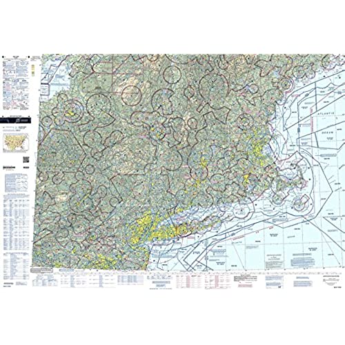
FAA Chart: VFR Sectional NEW YORK SNY (Current Edition)

(1745 Reviews)

Price
$7.05

Size
Quantity
(20000 available )

Total Price
Share
26 Ratings
22
1
0
2
1
Reviews
  • jer

    > 24 hour

    I like how quickly the product came to the house. It was exactly what I needed. The Aeronautical charts of Stewart Airport and surrounding airports in New York for flying drones

  • Brian Parr

    > 24 hour

    I also needed one for training purposes and this fit the bill.

  • Rebekah Lowell

    > 24 hour

    Excellent.

  • SeekerHiker

    > 24 hour

    This chart shows you what you need to know if you are in an aircraft. nuff said.

  • Filament Yoda

    > 24 hour

    A lot of information to digest

  • Richard Emord

    > 24 hour

    Good product thank you

  • J. Sundquist

    > 24 hour

    It’s the current sectional for NY Metro as indicated by the valid to/from dates. Very happy with it. I used it to study for the Part 107 test.

  • Robert L. Pelletier

    > 24 hour

    charts

  • Larry K

    > 24 hour

    Theres not much to say except, this is the real deal. Its the official chart, so nothing else is or can be better. It takes a bit of practice and study however to understand what youre looking at.

  • Paul D Farber

    > 24 hour

    Good quality, cheaper than buying from FBO.

Any pilot who braves the skies of the crowded New England megalopolis needs the FAA"s New York Sectional Aeronautical Chart front and center at all times. As is characteristic of the FAA"s entire lineup of sectional charts, the New York Sectional contains such need-to-know aviation data as airport info (runway lengths, lighting, elevation, services available, surface type, etc.); airspace dimensions; VHF and LF/MF navigational facilities (frequency, ID, and channel); landmarks; cities & towns; elevation/topographic info; ATC entities and associated contact/radio frequencies; bodies of water; obstructions; and much, much more.The New York Sectional depicts what is considered by many to be the most crowded, complicated, convoluted airspace on the planet. This chart covers much of NY, PA, VT, NH, NJ, MA, CT, RI, and southern ME. Also included on the New York Sectional is the bustling airspace around Boston, New York City, and Philadelphia. Uses the standard 1:500,000 (6.86 nm per inch; 2.70 nm per cm) scale characteristic of sectional charts. Updated every six months. An info-rich, extremely valuable publication that"s should be a "no-go" item for every pilot who aviates in the area.

Related products

Shop
( 2171 Reviews )
Top Selling Products